
Waterfalls
Inside Graham County is the Snowbird Basin, once you get to the trail head, there are Four Waterfalls you can walk to. They are: Big Falls, Middle Falls, Upper Falls and Sassafras Falls.
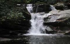
Big Falls
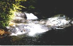 Even though the falls is name "Big Falls", the falls is a multilevel cascade which is definitely not "big". A steep side trail leads to the base of the cascade, where silky willow shrubs grow near a flat, rocky area.
Information About Big Falls
| Waterfall Height | Small multilevel cascade |
| Water Source | Snowbird Creek |
| Mountain | Snowbird Mountain |
| Owner | Nantahala National Forest |
| Trail Length (one way) | 3.9 miles |
| Trail Difficulty (10 = most difficult) | 3 |
| Beauty Rating (10 = highest) | 6 |
| Wheelchair Accessible | No |
| County | Graham |
Directions: From 129 / Tapoco Road in Robbinsville, turn left (west) onto NC 143. After 2.3 miles turn right onto SR 1127. Travel slightly more than 2 miles and bear left at a fork onto SR 1115. After 2 miles the road turns sharply to the left. After another mile, cross a bridge and turn right (and cross another bridge) onto SR 1120. The road dead-ends after 6 miles (4 miles of which is gravel) at the trailheads.
Middle Falls
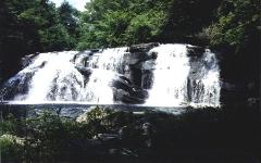 Of the Four waterfalls in the Snowbird Creek basin, Middle Falls is considered the best for photographing.
Information About Middle Falls
| Waterfall Height | 20 feet |
| Water Source | Snowbird Creek |
| Mountain | Snowbird Mountain |
| Owner | Nantahala National Forest |
| Trail Length (one way) | 5.1 miles |
| Trail Difficulty (10 = most difficult) | 3 - 7 |
| Beauty Rating (10 = highest) | 7 |
| Wheelchair Accessible | No |
| County | Graham |
Directions: From 129 / Tapoco Road in Robbinsville, turn left (west) onto NC 143. After 2.3 miles turn right onto SR 1127. Travel slightly more than 2 miles and bear left at a fork onto SR 1115. After 2 miles the road turns sharply to the left. After another mile, cross a bridge and turn right (and cross another bridge) onto SR 1120. The road dead-ends after 6 miles (4 miles of which is gravel) at the trailheads.
Upper Falls
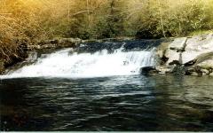 Upper Falls is small and hidden from view by overgrown vegetation. Most of the trail to Upper Falls is along an old narrow-gauge railroad grade. In the 1930's there was extensive timber logging the Snowbird Creek basin.
Information About Upper Falls
| Waterfall Height | Small Sliding Cascade |
| Water Source | Snowbird Creek |
| Mountain | Snowbird Mountain |
| Owner | Nantahala National Forest |
| Trail Length (one way) | 6.3 miles |
| Trail Difficulty (10 = most difficult) | 3 - 7 |
| Beauty Rating (10 = highest) | 4 |
| Wheelchair Accessible | No |
| County | Graham |
Directions: From 129 / Tapoco Road in Robbinsville, turn left (west) onto NC 143. After 2.3 miles turn right onto SR 1127. Travel slightly more than 2 miles and bear left at a fork onto SR 1115. After 2 miles the road turns sharply to the left. After another mile, cross a bridge and turn right (and cross another bridge) onto SR 1120. The road dead-ends after 6 miles (4 miles of which is gravel) at the trailheads.
Sasafras Falls
 Of the Four waterfalls in the Snowbird Creek basin, Middle Falls is considered the best for photographing.
Information About Sasafras Falls
| Waterfall Height | 50 feet |
| Water Source | Sassafras Creek |
| Mountain | Snowbird Mountain |
| Owner | Nantahala National Forest |
| Trail Length (one way) | 3.5 miles |
| Trail Difficulty (10 = most difficult) | 3 - 6 |
| Beauty Rating (10 = highest) | 5 |
| Wheelchair Accessible | No |
| County | Graham |
Directions: From 129 / Tapoco Road in Robbinsville, turn left (west) onto NC 143. After 2.3 miles turn right onto SR 1127. Travel slightly more than 2 miles and bear left at a fork onto SR 1115. After 2 miles the road turns sharply to the left. After another mile, cross a bridge and turn right (and cross another bridge) onto SR 1120. The road dead-ends after 6 miles (4 miles of which is gravel) at the trailheads.
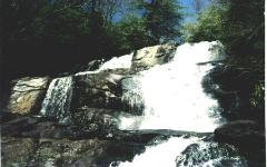
Wildcat Falls
 One of the many scenic stops on the Slickrock Creek trial. Wildcat Falls is four falls in close proximity with a crystal clear swimming hole at the bottom.
Information About Wildcat Falls
| Waterfall Height | Four Falls dropping 50' |
| Water Source | Slickrock Creek |
| Mountain | Unicoi Mountain |
| Owner | Nantahala National Forest |
| Trail Length (one way) | 2.6 miles |
| Trail Difficulty (10 = most difficult) | 3 - 6 |
| Beauty Rating (10 = highest) | 7 |
| Wheelchair Accessible | No |
| County | Haywood |
Other Falls
Another group of waterfalls are located in Bryson City by the Deep Creek Campsite. They are: Indian Creek Falls, Juneywhank Falls and Tom's Branch Falls.(Deep Creek Campsite is about 1hr from Fontana)
| Waterfall Height | 25 Feet |
| Trail Length (one way) | 1 mile from campground |
| Trail Difficulty | Easy |
| Wheelchair Accessible | No |
| Town | Bryson City |