
The Roads
Although The Dragon is by far the road that this area is known for, there are many other roads that deserve a look at too. So here is some info on The Dragon and more...
Here are some Printable Drive PDF's leaving from Fontana |
||
| Cherohala Skyway to Telico Plains | Hellbender/Moonshiner 28 to Franklin | The "Robbinsville" Loop |
| Scenic Drive (Dragon Lite Version) | The "Robbinsville Bonus" Loop | |
The Dragon
Crossing Deals Gap at the Tennessee/North Carolina state line, the Tail of the Dragon is considered by many as one of the world's best motorcycling and sports car roads. Anyone looking for an exciting highway adventure will enjoy the Tail of the Dragon stretch of US 129.
Riders and drivers from all over the USA and many foreign countries come to enjoy our many mountain roads. The Tail of the Dragon is usually the biggest attraction for thill seekers. The eleven miles features 318 curves none of which are the same. There are no buildings or driveways along the roadside, just the Great Smoky Mountain National Forest on the north side and a large forested area owned by Alcoa Aluminum on the south side.
The Dragon begins on the North Carolina side at Fugitive Bridge with a view of the Cheoah Dam where Harrison Ford jumped in the movie The Fugitive. It ends 14 miles across the mountain at the Tabcat Creek Bridge in Tennessee. US 129 climbs through The Slide, a steep series of "S" curves. The road then levels and straightens until a series of curves approaching Deals Gap and the Tennessee State Line. We'll leave the next eleven miles and 318 curves for you to describe after you ride it. Many just remember curve after curve after curve and surviving the run of their lives.
Facts About The Dragon:
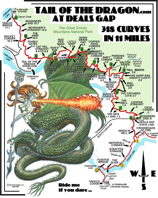 Total Distance:
Tabcat Bridge to Deals Gap - 11.1 Miles
Tabcat Bridge to Hwy - 11.8 Miles
Tabcat Bridge to Fugitive Bridge - 14.0 Miles
Elevation Change:
Tabcat Bridge to Deals Gap - plus 1085 Feet
Tabcat Bridge to Fugitive Bridge - plus 321 Feet
Click on the small map to the left to view a larger version.
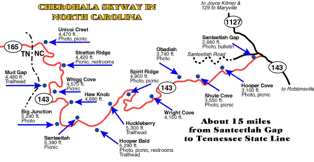
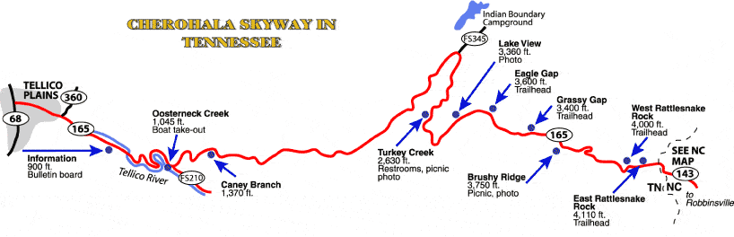
The Cherohala Skyway
The road crosses through the Cherokee and Nantahala National Forests thus the name "Chero...hala". The Skyway is becoming well known in motorcycling and sportscar circles for it's long, sweeping corners and scenic views. The Cherohala is 36 miles long. The Cherohala Skyway is 21 miles long on the Tennessee side. It follows the Tellico River (elevation about 900 feet) for a few miles before beginning its climb to the state line at over 4,000 feet. The Cherohala Skyway is only 15 miles long in North Carolina but the road reaches its highest point at the Santeetlah Overlook. The elevation change is much more pronounced rising from 2,660 feet to 5,390 feet in just over 10 miles.
Caution: The Cherohala, with its sweeping curves, will tempt you to ride fast and one of the occassional tighter curves can surprise you. There are more deaths on the Cherohala than on the Dragon. Many of the worst curves have guardrailing that we guarantee you do not want to hit. Emergency help on the Cherohala can be 45 minutes away and then a 30 minute helicopter transport. Please ride the Cherohala with extreme respect and use caution.
Cherohala - North Carolina side
Cherohala - Tennessee side
Highway 441(thru the Great Smoky Mountains National Park)
This 34 mile highway runs through the Great Smokey Mountains National Park. Starts off in Cherokee, North Carolina and ends in Gatlinburg, Tennessee. Beautiful views at every turn. One of my personal favorites as far as scenery. Traffic can be heavy.
The Foothills Parkway
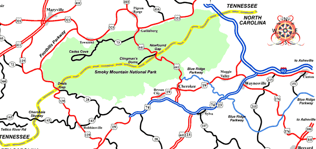 The Foothills Parkway links the Little River Road with the Dragon (US 321 to US129). The speed limit on this rather straight, little traveled 21-mile stretch of highway is 45 mph. There are some great views along this road.
The Blue Ridge Parkway and Skyline Drive
The Blue Ridge Parkway stretches 469 miles from Cherokee, North Carolina to Waynesboro, Virginia. The Skyline drive is a additional 105 miles from Front Royal, Va to where it connects to the Blue Ridge Parkway at Waynesboro, Va.. Click HERE for a Map
Need more info? Try these Links
![]() Tail of the Dragon.com. Shop, Dragon News, Maps and just about anything you can think of that is Dragon related.
Tail of the Dragon.com. Shop, Dragon News, Maps and just about anything you can think of that is Dragon related.
![]() Deal's Gap.com. This is the Motorcycle resort at the start of the Dragon. They have a store on site and online. Their site also has lots of great Dragon info.
Deal's Gap.com. This is the Motorcycle resort at the start of the Dragon. They have a store on site and online. Their site also has lots of great Dragon info.